Wat Ta Vong
| Native Name | វត្តតាវង្ស |
|---|---|
| Alternative name | Wat Tavong |
| BA# | C0103151 |
| Size | Unknown |
| Condition | Unknown |
| Type | Temple, Wat |
| Location | |
| Part of | Phum Ta Vong |
| Village | Ta Vong |
| Commune | Ponlei |
| District | Phnom Srok |
| Province | Banteay Meanchey |
| Country | Cambodia |
| Coordinates | 13.77276, 103.23063 |
| History | |
| Verification | Unconfirmed |

![]()
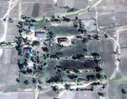
![]() Wat Ta Vong (វត្តតាវង្ស - Pronounced: Woht Ta Vohng)
Wat Ta Vong (វត្តតាវង្ស - Pronounced: Woht Ta Vohng)
According to historic satellite imagery it appears that the modern temple vihara was built on a possible temple mound site that was surrounded by a moat. Over the years it looks like the area has been filled in, as it doesn't show the area flooded no more.
Though we also suspect that maybe Wat Ta Vong was built on a former reservoir that may have sat to the east of Tuol Prasat Ta Vong.
Map Location
Image Gallery

If you would like to upload additional images to the gallery, please refer to the Upload Instructions guide
Historic Archive
A collection of historic photographs, artist sketches, maps etc. (Please ensure that anything you do upload is free of copyright and/or you have permission from the original photographer/artist/author to share)
Nearby Sites
- Baray Prasat Andaeuk
- Baray Prasat Chhkae Pha-eul
- Baray Prasat Po Roam Bon
- Baray Prasat Ta Na
- Baray Prasat Ta Vong
- C0103106
- C0103111
- C0103127
- C0103128
- C0103130
- C0103131
- C0103132
- C0103134
- C0103135
- C0103136
- C0103143
- C0103144
- C0104088
- C0108166
- C0108220
- C0108222
- Phum Po Roam Bon
- Phum Ta Vong
- Prasat Cheh
- Spean Reap
- Srah Prasat Chhkae Pha-eul
- Srah Trapeang Ta Ngil
- Trapeang A Hung
- Trapeang Andaeuk Thom
- Trapeang Andaeuk Toch
- Trapeang Khmau
- Trapeang Kho Snal
- Trapeang Kok Chas (Phnom Srok)
- Trapeang Prasat Sarong Lech
- Trapeang Prasat Ta Lum
- Trapeang Russei (Phnom Srok)
- Trapeang Sek
- Trapeang Ta Ngil
- Tuol Kopsop Badak
- Tuol Kopsop Kanhchhoan Kroch
- Tuol Kopsop Svay Khmau
- Tuol Kopsop Trapeang Ampil
- Tuol Prasat Andaeuk
- Tuol Prasat Baek Kruos
- Tuol Prasat Chhkae Pha-eul
- Tuol Prasat Damnak Sdach (Svay Chek) I
- Tuol Prasat Damnak Sdach (Svay Chek) III
- Tuol Prasat Kap Cheh
- Tuol Prasat Kho Snal
- Tuol Prasat Kok Prasat (Phkoam)
- Tuol Prasat Po Roam Bon
- Tuol Prasat Sarong Kaeut
- Tuol Prasat Sarong Lech
- Tuol Prasat Svay Khmau
- Tuol Prasat Ta Lum
- Tuol Prasat Ta Na
- Tuol Prasat Ta Ngil
- Tuol Prasat Ta Vong
- Tuol Prasat Trapeang Ampil
- Wat Ta Vong
External Links
Links to additional resources such as articles, websites, videos etc.
References